Driving the Ring Road - Iceland
- Allison Healy

- Oct 15, 2018
- 28 min read
Updated: Apr 20


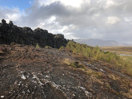
A grand sunrise. This is an amazing way to spend a morning after landing at the Keflavík Airport at 4 am. As you leave the airport, you enter a desolate landscape often described as "driving on the moon," with vast lava fields blanketed in moss. This drive provides a scenic introduction to the Reykjanes Peninsula, featuring rugged terrain and expansive ocean views as you make your way to Reykjavík.


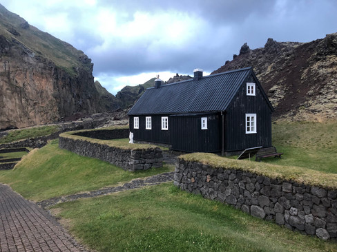
Hallgrímskirkja, a Lutheran church located in Reykjavík, Iceland, is renowned for its distinctive architecture and holds the title of the tallest church in the country. The design draws inspiration from Iceland's natural basalt columns. At the center of the church, the Hallgrímskirkja pipe organ stands as a masterpiece, harmoniously combining traditional and modern elements, embodying the church's modernist style. The Leif Eriksson Monument stands in the plaza directly in front of the church, a gift from the United States to the people of Iceland in 1930.


When you visit the iconic Hallgrímskirkja church, which dominates the city's skyline, you can head up to the bell tower for its panoramic views. I had the privilege of hearing the organ played live during the Lunchtime Concerts held on Thursday afternoons from September to May. The short "Meditation and Organ Music" performance was so beautiful it brought me to tears...

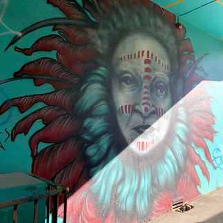


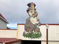
Reykjavik boasts a vibrant and diverse street art scene, transforming the city's urban landscape into an open-air gallery. Murals and graffiti, ranging from whimsical characters to thought-provoking social commentary, adorn buildings, alleyways, and even pavements. The art reflects both Icelandic culture and international influences, with many pieces resulting from collaborations between local and global artists.


Kex Hostel
Located in an old biscuit factory and decorated with salvaged materials, the Kex Hostel has an eclectic feel that’s impossible to miss. The hostel's industrial aesthetic, featuring salvaged materials and found objects, creates a distinctive and memorable environment. It’s also known locally for hosting the best musicians in town. It is recommended as the place to be in the evening. There was convenient street parking for the car rental, which was free during the evening. This worked out well since I had to be on the road early the next morning... kexrvk.is


When the Icelandic bartender at the hostel casually mentions, "You are going to drive the Ring Road, for your spirituality," it resonates deeply, hinting at the transformative journey that lies ahead. The Ring Road, or Route 1, is not just a highway; it is a captivating route that encircles the entire island, offering breathtaking views of Iceland’s diverse landscapes, from glistening glaciers and majestic waterfalls to rugged coastlines and volcanic craters. This statement encapsulates the essence of what many travelers experience—an awakening of the spirit through the stunning natural beauty and the serene isolation that this unique country provides.
I would wholeheartedly recommend this particular hostel as an ideal location for a budget-friendly stay. The atmosphere here is warm and inviting, filled with fellow travelers eager to share their stories and experiences. The accommodations are comfortable yet affordable, making it possible for you to stretch your budget while still enjoying the rich culture and breathtaking scenery that Iceland has to offer.
Before embarking on your journey northward along the Ring Road, take some time to explore the town. The local area is brimming with charming cafes, artisan shops, and cultural landmarks that are worth your attention. You might want to visit the nearby museums to gain insight into Icelandic history and culture, or perhaps enjoy a stroll through the picturesque streets that showcase the unique architecture of the region. Gathering resources is also crucial; consider picking up a map or downloading helpful apps that provide information on points of interest along the Ring Road. Additionally, stocking up on snacks and supplies will ensure that you are well-prepared for the adventure that awaits you. With the right preparations and a spirit of exploration, your journey along the Ring Road promises to be not only a scenic drive but also a profound experience for your soul.


Reykjavik
Walking around Reykjavik, the capital city of Iceland, is an experience that is as captivating as it is unique. The moment you step onto the streets, you are greeted by a blend of modern architecture and traditional Icelandic structures. As you stroll through the streets, you might find yourself wandering along Laugavegur, the main shopping street, with an eclectic mix of boutiques, cafes, and art galleries. The street is often bustling with both locals and tourists, creating a lively atmosphere that is infectious. You may come across Harpa Concert Hall, an architectural masterpiece by the waterfront, known for its stunning glass facade that reflects the light beautifully. Walking around Reykjavik is not just about the sights; it is also about the people. You may find yourself engaging in conversations at a cozy café or joining a guided walking tour that delves into the city’s history and folklore. Each step taken in this vibrant city reveals something new, making it a destination that invites exploration and discovery at every turn.


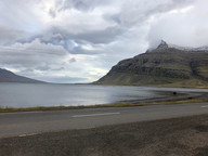
Driving North
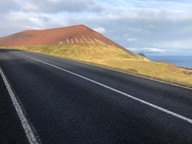
From Reykjavik, Snæfellsnes Peninsula can usually be reached by car in 2.5 to 3 hours under good conditions. At every turn, you'll find another rainbow, intriguing churches, and beautiful Icelandic horses. The views become increasingly breathtaking as you move away from the capital. I've driven around rocks where the road's deviation seemed unnecessary. I suspect this is where the "hidden people" reside, though I haven't confirmed this with the locals.


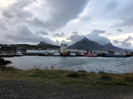
The Freezer Hostel
The Freezer Hostel & Culture Centre is a unique, award-winning social hostel located in a former fish factory in the small Icelandic fishing village of Rif on the Snæfellsnes Peninsula. It's known for its lively atmosphere, artistic vibe, and as a hub for Icelandic arts and culture. The hostel offers a variety of accommodations, including dorms, private rooms, camping spaces, and apartments, alongside a social lounge, bar, and theater.
They offer cheap accommodation, regular events, and entertainment for guests and the local community all year round. You should check them out... www.thefreezerhostel.com


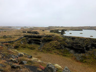
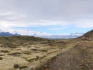
Exploring Snæfellsnes Peninsula
The Snæfellsnes is a peninsula located to the west of Borgarfjörður, in western Iceland. This area is known for its unique features, earning the nickname "Iceland in Miniature" because of its varied landscapes. The peninsula has a volcanic origin, with the Snæfellsnes volcanic belt running through its center, and the Snæfellsjökull volcano, a renowned symbol of Iceland, at its western end. It is the peninsula's highest mountain and has a glacier at its summit.


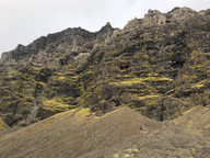
Hiking Near Snæfellsjökull
Explore the park by driving along the coastal roads and stopping at beaches, lava fields, and scenic viewpoints. Be sure to wear durable, waterproof hiking boots, as the trails can be rocky, wet, and windy. While I didn't hike on the glacier itself, the surrounding landscape provided ample sights for the day. In the future, having a guide to safely explore the glacier would be an amazing adventure.


Desolation
I feel like here all my wishes sparkle
in a strange fairytale,
you purple, silent wasteland
with white towers and roofs in every way.
Your deep embrace of peace opens up to me
and my poverty to a rich heart web.
And the glacier bulge is curved
its breast, which gives less power to the soul.
Alas, receive me, land of light nights,
and let thy waters drown my sorrows
and bury my sins in thy sand,
- then I sleep better under your cheeks.
They listened to the heath
A still blur of the heath is stirring
Mime and death dead,
Whispering in a wide range of eyes
The flowers by the river.
Felt in the sky, quiet on earth,
Autumn leaves from the west approach a mask.
However, play a skin for a low guard
Past due time.
Blue-tailed river, the bladder set,
The flowers and the tree our minds interprets:
One time here was a young boy
Catalyst girl.


Saxhóll Crater
A 109-meter volcanic scoria cone situated at the western end of the Snæfellsnes Peninsula. It is renowned as one of the most accessible craters in the country, with an award-winning metal staircase guiding visitors to the top for panoramic views of the Atlantic Ocean, lava fields, and the Snæfellsjökull Glacier. The ascent includes around 385 shallow metal steps and usually takes about 20 minutes. Entry and parking are free, and the site is open 24 hours a day, year-round.


The crater was created approximately 4,000 years ago during a single, explosive phreatomagmatic eruption. Local legends propose that the crater might serve as a gateway for elves and fairies. At the top of the Saxhóll Crater, there is a compass rose orientation disk, often called a navigation or orientation marker, which assists visitors in identifying the surrounding landmarks in the 360° view. The staircase, crafted by Landslag landscape architects, received the Rosa Barba International Landscape Prize in 2018 for its sustainable design that safeguards the delicate volcanic soil.


Because the crater is highly exposed, the metal platform holding the disk is subject to extremely strong winds. It's recommended to stand firmly while viewing the marker, as "gale-force winds" are common at the summit. The intense winds at the crater's peak definitely challenged my balance. Nevertheless, it was an incredible experience.


Djupalonssandur Beach
Beginning at the Nautrastígur path leading to Djúpalónssandur beach, the trail winds through a striking landscape of moss-covered lava formations, often referred to as a "lava wonderland." In the past, this region was a bustling fishing station, with this path serving as the primary route for fishermen reaching the cove. The distinctive rock formations are frequently linked to folklore, with tales of elves and trolls. At the beach entrance, four large boulders, known as ancient lifting stones, were traditionally used to test the strength of prospective fishermen. The beach is renowned for its smooth black pebbles, called "Djúpalónsperlur," or Pearls of Djúpalón. Scattered across the beach are rusty iron fragments from the British trawler Epine GY 7, which wrecked during a 1948 blizzard. These fragments are preserved as a memorial to the 14 crew members who perished.


Extreme Caution Required. Currents at Djúpalónssandur are exceptionally powerful and dangerous. Swimming is strictly prohibited, and visitors should stay at least 25–40 meters back from the water. Sneaker waves appear suddenly after long periods of calm surf, often surging dozens of feet further up the beach than expected. Always keep the ocean in your line of sight.

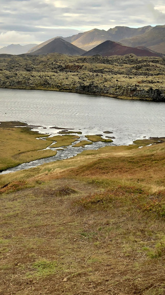
Landscape view of Selvallavatn Lake on the Snæfellsnes Peninsula. The lake is situated along Vatnaleið mountain pass, which connects the north and south coasts of the peninsula. The view is captured from the Selvallavatn View Point in Bjarnarhofn, offering a panoramic look at the lake and the rugged, mossy hills.


Bjarnarfoss is a waterfall with two levels, dropping about 80 meters down a high cliff. Local folklore tells of a fairy woman, the "Lady of the Mountains," who bathes in the middle the falls. Selvallafoss, also called the Sheep's Waterfall, is another well-known natural site on the Snæfellsnes Peninsula in West Iceland. A unique aspect of Selvallafoss is that visitors can walk behind the flowing water. The path can be muddy and slippery, particularly around the moss-covered rocks behind the falls. The name "Sheep's Waterfall" is derived from the area's rich greenery, which provides grazing for Icelandic sheep.


Northern Coast of the Peninsula
The northern coastline of the Snæfellsnes Peninsula is characterized by striking, steep fjords, verdant coastal plains, and volcanic summits. As you travel along Route 54, the scenery shifts from lava fields to the slopes of Grundarfjörður, ending at the renowned, solitary "Arrowhead" mountain, Kirkjufell, frequently highlighted by the adjacent Kirkjufellsfoss waterfall.

Kirkjufell
Kirkjufell, which translates to "Church Mountain," is among Iceland's most famous and frequently photographed sites. The quintessential photograph of Kirkjufell includes the nearby three-tiered Kirkjufellsfoss Waterfall in the foreground. This mountain is a "nunatak," meaning it was a peak that stood above the surrounding glaciers during the Ice Age. Its layers consist of basalt and sedimentary rock filled with fossils. When I visited, I came across a small group of professional photographers trying to capture the ideal shot. You might have to wait a bit for an unobstructed view without anyone in it.


Leaving Snæfellsnes Peninsula
Traveling northeast from the Snæfellsnes Peninsula to Hvammstangi takes you from the striking, compact volcanic scenery to the expansive, rolling farmlands and deep fjords of the North. By following Route 54 east from Stykkishólmur, you journey along the southern edge of Breiðafjörður bay. This route includes a combination of paved and gravel sections, offering views of numerous small islands scattered across the water. Opting for the inland shortcut via Route 59 leads you through a remote, high-altitude moorland. This region is often quieter and feels more "wild," with marshy plains and grazing sheep. As you near Hvammstangi, the landscape unfolds into the Vatnsnes Peninsula, famous for its coastal seal colonies and the Hvítserkur sea stack.


Hvammstangi Campground
Hvammstangi, the largest town in Hunathing Vestra, and is an ideal destination for travelers looking for a place to rest. The Kirkjuhvammur camping site in Hvammstangi is situated just 6 kilometers from the Icelandic Route 1, halfway between Reykjavik and Akureyri. Located in a sheltered valley just outside the town, the site offers a well-equipped service station and excellent facilities for campers... kirkjuhvammur.is


Driving North
Driving east from Hvammstangi to Húsavík takes about 3.5 hours without stops. The journey primarily follows Iceland's main Ring Road before branching off to the coast. You will traverse rolling hills and agricultural heartlands. To reach Húsavík, you will exit the Ring Road and head north on Route 85, which leads directly into the town.


Strange sculpture on the road to Húsavík, appeared to be slightly phallic, and I think that I am correct. Jóhann Sigurjónsson (1880–1919) was an Icelandic playwright and poet. Jóhann wrote plays and poetry in both his native Icelandic and in Danish.
Á hvitum hestum hleyptum við
upp á bláan himinbogann
Og lekum að gylltum knöttum
On white horses we rode
up to the blue sky
And played with golden balls


Húsavík
Húsavík is the oldest settlement in Iceland and the largest town in the Þingeyjarsýsla district, serving as the service center for the surrounding region. The town is renowned for its whale watching tours in Skjálfandi Bay and is frequently called the Whale Capital of Iceland. The Húsavík Museum features permanent folk and maritime exhibitions that provide a lively glimpse into the area's historical life. Additionally, there are two galleries showcasing a wide variety of multi-annual art exhibitions.
Due to weather conditions, all boat trips from the north were canceled for three days, which meant I unfortunately missed the chance to see any Arctic whales on this trip. Nonetheless, I was pleased to receive a refund. The staff at the docks were very helpful and kind upon my arrival, and they provided some recommendations for my visit to Húsavík... www.northsailing.is


Akureyri
Affectionately referred to as "Iceland’s Capital of the North," Akureyri is Iceland’s second-largest city. However, calling Akureyri a city might be an exaggeration since its population is just about 19,000, so it is more of a town. A vibrant cultural scene, including the Akureyri Art Museum, the Hof Cultural Center, the iconic Akureyri Church, Akureyrarkirkja, and the world's northernmost botanical garden. It is also worth noting that the stoplights feature glowing red hearts instead of solid circles.


Strípar
Associated with the geological features around Kálfastrandarvogar in North Iceland, near Lake Mývatn's lava pillars, referring specifically to the particular formation rather than the general area. The term "strípar" can be a plural noun, sometimes used to describe barren or stripped features.


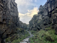
Dimmuborgir
Referred to as the "Dark Fortress," this landscape is abundant in geological marvels and folklore. The Dimmuborgir region consists of diverse volcanic caves and rock formations, resembling an ancient fallen citadel, which is why it bears this name. The area originated over 2,300 years ago due to a volcanic eruption, resulting in these distinctive deep caverns and formations.
In Icelandic folklore, Dimmuborgir is considered a connection between the earth and the underworld. In Nordic Christian tradition, it is thought that Dimmuborgir is the place where Satan landed after being cast out of heaven, forming what is referred to as the "Helvítis katakomber," meaning "The Catacombs of Hell."

"New hiking trail through a delicate area, follow the markers."


"The rim of Hverfjall crater reaches 80 to 180 metres above the surrounding area. It belongs to a crater row that includes some of the most beautiful and well-formed tephra craters in Iceland. The crater is believed to be among the largest of its type on the planet and the diameter at the rim is over 1000 metres.
Hverfjall is at the southern-most end of a 1800 meter long eruption rift and was formed during a large phreatic eruption about 2500 years ago. The magma came into contact with water which caused large steam explosions. The explosions ripped the magma apart, forming the tephra and scoria that the crater is made out of. Pyroclastic materials were ejected from the crater in two ways. Firstly the crater formed large clouds of ash that rained down over a large area. Secondly the tephra caused pyroclastic flows on the slopes of the crater that reached up to 3 kilometres from the crater. Traces of the flows, in the form of layered tuff hills, can mainly be seen to the north of Hverfjall, for instance at the Nature Baths.
The view from the crater is truly panoramic and overlooks the lava fields all around and the lake to the west. Looking south from the crater hikers can behold Dimmuborgir with a birds eye view."


Walking along the rim of Hverfjall is akin to setting foot on the Moon's surface, where a stark, monochrome expanse of crushed black tephra extends in a vast 1 km circle. As you traverse the broad, gravelly path, the enormity is awe-inspiring; the crater’s floor plunges into a silent bowl, while the 360° views showcase the contrasting blues of Lake Mývatn and the steaming geothermal vents of Námaskarð on the horizon. The experience is characterized by the crunch of volcanic ash beneath your feet and the relentless, biting Arctic wind sweeping across the exposed ridge, making you feel small against the backdrop of Iceland’s raw geological power.


Grjótagjá was a popular bathing place for several decades until the 1975-84 volcanic eruptions at Krafla brought magma streams under the area resulting in a sharp rise in water temperature to nearly 60° C. Today the water is in the range of 43-46° C.
Entering the caves possess the danger of falling rocks and is solely on your own risk. The public is prohibited from bathing or use of caves for purposes other than for inspection and photography. Violation of these rules can result in expulsion from the area. The land is in private ownership of the Vogar farm. Please be respectful to the nature.


In Iceland, sheep are a frequent traffic hazard as they roam freely on the roads, typically moving in groups. They often graze along the roadsides, rest on the warm asphalt, and have a tendency to suddenly dash across the roads. This behavior necessitates that drivers slow down and exercise patience.


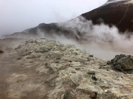


Hverir Geothermal Area
This small geothermal area features active mud pools and steam vents, accessible via a brief walk from the parking lot. The terrain is largely desolate, with steam emanating from the earth and mineral-stained soil highlighting zones of geothermal activity. At Hverir, the mud pools contain dense grey and brown mud that bubbles as hot gases rise from beneath. The activity differs among the pools, with some bubbling softly while others do so more energetically. Mineral deposits surrounding the pools form noticeable patches of yellow, red, and orange on the ground.
Fumaroles, or steam vents, emit hot steam and volcanic gases into the atmosphere across the region. These vents may create hissing or roaring noises, influenced by subterranean pressure and weather conditions. A distinct sulfur odor is frequently detectable, especially on calm days with minimal wind. A designated gravel path leads you through the most active part of Hverir, enabling them to observe the mud pools and steam vents up close from a safe distance.


The names Namafjall, Hverir, and Namaskard are often mentioned together, which may initially be confusing. They are all part of the same geothermal area east of Lake Myvatn, but each denotes a different landscape feature. Namafjall is the mountain that overlooks the geothermal field, easily visible from the road with its slopes colored red and yellow due to the minerals in the soil. A walking trail leads to the summit, offering expansive views of the surrounding hills and steam vents below. Hverir is the geothermal field at the base of the mountain, featuring steaming vents, bubbling mud pools, and a strong sulfur smell that defines the area. The ground here is hot and soft, so it's crucial to stay on the marked paths for safety. Namaskard refers to the mountain pass next to Namafjall, where similar geothermal activity occurs, and steam often rises from the ground as you drive through. All three locations are part of the same geothermal system within the Krafla Volcanic Region.
This landscape felt like being on another planet. It would be a fantastic location from which to collect soil samples for paint, but I wouldn't do so without explicit permission. Given the dangerously high soil temperatures, this probably wouldn't be recommended anyway. I could only remain here for around 30 minutes because the sulfur odor became unbearable quickly.


"Caution: Unsafe soil and high temperatures (80-100°C)! Please walk on the paths and marked trails."


Driving through the Central Highlands
Traveling through the Central Highlands is a rugged, "off-the-beaten-path" adventure marked by expansive volcanic deserts, glacial vistas, and a lack of permanent settlements. Unlike the paved Ring Road, access to the interior is via F-roads, which are unpaved gravel paths that often require crossing unbridged rivers. Officially designated as uninhabitable, it is one of the largest unpopulated wilderness regions in Europe. There are no permanent residents, towns, or villages in this area. Be sure to refuel whenever possible, as this area is remote!


Camp Egilsstaðir and Tehúsið Café
A delightful encounter with a fellow traveler. We had a brief chat, and she was hitchhiking solo, which is perfectly legal in Iceland. She was taking a break from the bad weather at the hostel's coffee shop near the campsite in Egilsstaðir. Her piano playing was wonderful!


Having a 'kaffee' in Egilsstaðir before hitting the road again. Tehúsið Café is reputed to be the best in town. I brought my own instant coffee for camping, which is wise if you're traveling on a budget, as coffee tends to be expensive here. This café is an excellent place to catch up on work because they have reliable Wi-Fi, and I enjoyed listening to some early Björk on vinyl... tehusid.is


Hengifoss and Litlanesfoss Waterfalls
Hengifoss ranks as the third highest waterfall in the country, majestically reaching approximately 128 meters in height. The Hengifoss River features a stunning series of waterfalls, with Hengifoss being the most notable. The edge of the waterfall is situated about 450 meters up the hillside, creating a striking silhouette against the sky from the valley below. The waterfall cascades into a dramatic yet beautiful gorge that forms a large bowl in the hillside. The gorge walls consist of basalt columns with distinct red layers interspersed between them. Below the waterfall lie thick sedimentary layers that were formed 5 to 6 million years ago. At the top of these layers is lignite, the remnants of a vast forest, where pieces of tree trunks and roots can occasionally be seen, compressed by the earth's weight. Basalt lava once flowed over the forest in this depression, and sedimentary layers later accumulated on top. Two streams, both called Sellækur, descend in waterfalls and rapids into the gorge.
Litlanesfoss is situated halfway up the hillside, approximately midway to Hengifoss. Although not very tall, standing at about 25-30 meters, it is encircled by a stunning columnar basalt formation featuring unusually tall columns. This formation has been likened to a wide, tall choir, with the straight columns resembling organ pipes. Beneath Litlanesfoss, there are a series of sedimentary layers.
Basalt Columns
After lava solidifies, the rock continues to cool for a considerable time, forming columns that are frequently hexagonal. Such columns always lie at right angles to the cooling surface, and are therefore vertical in lava layers and horizontal in intrusions (dikes). At Litlanesfoss, the lava seems to have filled a stream bed and cooled slowly, forming beautiful columnar patterns. The tallest columns are slightly curved at the top, indicating that the lava was still slightly in motion when the columns began to form.


Öxi Pass
In East Iceland, the Öxi Pass (Route 939) serves as a 19km gravel shortcut connecting Egilsstaðir and Berufjörður, reducing the coastal Ring Road journey by approximately 70km. Although it offers beautiful views, the pass is narrow and steep, with gradients of 17-20%, and is frequently closed during winter or adverse weather conditions. It is typically not recommended for nervous drivers or standard vehicles.
Traveling through fjords amid strong winds and sporadic snow can be a truly terrifying experience! Once I descended, the snow subsided, but I faced very steep slopes and numerous blind curves on the gravel roads of this pass. Each turn potentially hazardous, keeping my adrenaline levels elevated.
Certainly not for the faint of heart, this winding path is characterized by its steep inclines and sharp turns that demand both skill and concentration. You will encounter breathtaking vistas that stretch across the horizon, revealing stunning landscapes that can be both awe-inspiring and intimidating. The road often hugs the edge of cliffs, providing exhilarating views of the valleys below, but also presenting a challenge as the drop-offs can be quite steep. Some of the curves had guard rails, which was super nice of them! The surface of the road varies, with some sections paved smoothly while others are rough and uneven, requiring careful navigation. Weather conditions can also play a significant role in the driving experience; rain can make the road slick and treacherous, while fog may reduce visibility to mere feet, adding an extra layer of difficulty. Driving on this road is not just about reaching your destination; it's an experience that tests your driving abilities and offers a sense of adventure, if you are into that sort of thing. I was definitely white-knuckling this part of the journey... I did see a car that had flipped over right after I got through the rough patch that was pretty mangled. That will make your heart stop! I hope everyone got out of it okay. The Vegvísir symbol has a new meaning for me now.


Driving the East Fjords into the Night
While journeying through the East Fjords, I passed by salmon fisheries and quaint coastal villages and discovered a small whale gallery featuring an impressive skeleton. Now, I'm en route to my next overnight stay at the Haukafell Campground. I traveled in the dark, following the offline road map until I arrived at the marked location.


Haukafell Campground
The campsite is quite basic; the water supply might be unreliable, and showers are not available. However, the stunning natural surroundings are ideal for exploration and compensate for the absence of modern conveniences. Haukafell Farmhouse was originally located a short distance from the current campsite from 1880 to 1936. It was relocated here when the original site was threatened by a glacier. Although many attempted to farm the land, few remained for long. In 1936, the farmhouse was abandoned, and its materials were repurposed for constructing nearby farms.
Fláajökull Glacier
Although you can view Fláajökull Glacier from the campground, a 5km circular hike will lead you to a breathtaking vantage point across the glacier. Fláajökull, meaning “Sloping Glacier,” is a small extension of the larger Vatnajökull Ice Cap, located on the eastern side of Breiðabunga Volcano. Like many glaciers, it has receded more than two kilometers in the past century, once posing a threat to Haukafell Farmhouse. The hike starts by following the tree line from the campsite before descending to the river. A metal bridge spans the river, and from there, a trail leads towards the glacier lagoon. There is also a second, slightly shorter trail that begins on the opposite side of the river.


Heading South
After departing from the campsite and replenishing my water supply, I resumed my journey south towards Vík. With every turn, the landscape transformed, revealing vast moss fields that extended for miles. The terrain resembled green polka dots scattered across light sand-colored expanses.


Jökulsárlón
Jökulsárlón is the largest glacial lake in Iceland, situated within Vatnajökull National Park in the southeast of the country. The lagoon is positioned at the terminus of the Breiðamerkurjökull glacier, which extends from the larger Vatnajökull ice cap. The uniqueness of this location lies in the ice chunks that detach from the glacier and glide across the lagoon before eventually reaching the ocean. These icebergs display a range of shapes and feature blue and white hues that change with the light.
Lagoon Wildlife
While visiting Jökulsárlón, seals gracefully navigate through the floating icebergs, diving beneath the surface to catch fish. This location offers some of the country's best wildlife encounters. Visitors can watch the seals from the shore or choose a boat tour for a closer look at these graceful swimmers.


Eldhraun Lava Field
Covering approximately 565 square kilometers, the Eldhraun is the largest lava field in the world by area. Located between Vík and Kirkjubæjarklaustur, it was formed during the Laki eruption from 1783 to 1784. Today, the field is covered with a dense layer of wooly fringe moss, offering a soft, pale green appearance that stands out against the rugged lava surface beneath. With a dramatic sunset, this landscape becomes even more surreal.


Laufskálavarða
One unusual roadside feature is a field of rock piles resembling clusters of tiny mountains spread across the landscape. Laufskálavarða is a lava ridge located just off the main Ring Road. Traditionally, first-time travelers crossing the black sands of Mýrdalssandur would create small stone stacks for good luck. As more people embarked on their journeys, the number of cairns increased, resulting in the expansive display seen today.
Throughout Iceland, there are numerous other cairns. For centuries, these stone stacks served as navigational markers for locals. Early settlers constructed them to indicate trails or significant locations, and this practice expanded over time. Currently, however, visitors are advised not to create additional cairns in the countryside. With the influx of tourists, any new rock piles could harm the environment and the existing cultural heritage.


Vík í Mýrdal
The southernmost village in Iceland, Vík, is situated near the renowned black sand beach Reynisfjara and the Reynisdrangar cliffs. It's a very small village with limited amenities, but I was able to find sustenance at The Soup Company. While some cafés might offer refills, few restaurants extend this generosity to entire meals. This unique policy distinguishes The Soup Company, as all guests are welcome to enjoy a second bowl of soup at no extra cost... thesoup.company
When I arrived at the hostel in Vík, my scheduling error led them to offer me their camping bus. I'm much happier with this arrangement, and I could have easily been out of luck since they were fully booked. Now, I have the bus all to myself, bundled up with a space heater, a big comfy blanket, electricity, and WiFi. How often can you say you slept in a red bus in Vík, Iceland? Life is an adventure.

Lifðu og gefðu
Þó sortni um stund þá sérðu
og sjálfgefnu leiðina ferðu
ef hrein er pin lund
á gleðinnar fund
fagnandi, lifðu og gefðu
Live and give
Though it be dark for a while, you will see
and the path you have chosen
if your heart is pure
to the joy of
rejoicing, live and give


Skogafoss
Skógafoss, located on Iceland's South Coast near the village of Skógar and just off the Ring Road, is one of the country's most famous and largest waterfalls. It is recognized for its perfect rectangular shape, a thunderous 60-meter descent, and the vibrant single or double rainbows that frequently appear in its mist on sunny days. If you plan to get close to the base, wearing waterproof clothing is essential, as the spray can drench you almost instantly.


The Ferry
Vestmannaeyjar awaits! Traveling to the Westman Islands by ferry from Landeyjahöfn with Herjólfur takes about 40 minutes. While on the ferry, you can relax in the cafeteria and enjoy a refreshment. Traveling with Herjólfur offers an affordable, comfortable, and pleasant journey to Vestmannaeyjar. The route from Landeyjahöfn is fascinating, with scenery unlike anything I've seen before..


The Side Quest
On the ferry, I encountered some friendly Icelandic folks who were enthusiastically reciting sports chants. I caught the word "Minnesota" amidst their Icelandic conversation and joined in, asking, "Did you just say Minnesota?" One of them responded with "SKOL!" Before long, I was invited to a football game on the island. I graciously accepted the invitation, and when the ferry docked, I navigated my way to the field by trailing the sound of those familiar chants. They were lovely. When in Rome!


Heimaey History
The first people known to make landfall on Heimaey were two escaped slaves, and they would not live their long. The two men, who were Irish and captives of the foster brother of Reykjavík’s founder, Ingolfúr Arnarson, killed their master and fled here in order to avoid vengeance. Arnarson, however, found the body before they could make a clean escape, and saw their boats headed to the uninhabited islands off the South Coast. He followed them and hunted them down, killing one and driving the other to throw himself to his own death off of a cliff. As the Irish were then known as ‘Westmen’, the islands of the archipelago that include Heimaey have been called the Westman Islands ever since. The hill that the slave threw himself off has since been named after him, as Duffy’s Hill, or Dufþekja.
It is possible that there were settlers on Heimaey before even these slaves reached it, as a recent archaeological dig showed evidence of homes from around 800 AD, years before Ingolfúr was even born. According to the Book of Settlements, the first person to make a permanent home there did in 900 AD. The population of Heimaey slowly grew, as more settlers arrived, families expanded, and the fertile fishing waters around it became known. The Danish established buildings there once they took control of Iceland, showing its significance as a port.
However, tragedy would strike in 1627: pirates. Likely hailing from the Algiers, and part of the Barbary Fleet that the Ottoman Empire used to terrorize the seas at the time, they raided Iceland’s coasts and islands. While, on the mainland, Icelanders could flee into the nature, on Heimaey they had nowhere to go, and 237 people were captured. Less than a hundred returned to Iceland; most of the rest sold on the slave market. The terror and pain the people captured endured was written about by a priest who miraculously survived. The struggles endured by the people of Heimaey would not end there, although no major incident would arise on the island for other three centuries.
In 1973, the residents of Heimaey woke up to an eruption tearing through the middle of their town. Fissures over a kilometer in length snaked through the houses, and lava and ash destroyed over 400 homes. As unexpected and terrible as it was, the response was incredible, and all 5,300 residents were whisked to the mainland safely. Only one is thought to have died as a result of the eruption.


Landlyst
"Landlyst was built between 1847-1850 by the carpenter Matthías Markússon and his wife Solveig Pálsdóttir, and is the second oldest house in Vestmannaeyjar, only the Landakirkja church is older. The house stood at Strandvegur 43b until 1992, when it was disassembled, protected and then reassembled in almost original shape at Skansinn in the year 2000.
The neonatal tetanus disease (tetanus neonatorum) was commonplace in Iceland but quite severe in Vestmannaeyjar since the 17th century. In the year 1842 it was estimated that every three out of four children born alive, died from the disease. It was believed that the disease, which was characterized by cramps, was caused by water deficiency, fish or bird consumption or even Fulmar feathers.
Solveig Pálsdóttir (1820-1886), a priest daughter from Kirkjubær in Vestmannaeyjar sailed to Copenhagen in 1842 to study to become midwife and to take care for infants. Solveig was the first educated midwife residing in Vestmannaeyjar and one of the very first Icelanders to receive a midwife education abroad.
The arrival of the Danish doctor of medicine Peter A. Schleisner (1818-1900) in 1847 was pivotal for the fight against the neonatal tetanus disease. In collaboration with Solveig he established a special birth-infirmary "Stiftelsið", which was built at the west end of Landlyst and paid for by a grant from the Danish state. It was commonplace to dry laundry on stonewalls which were exposed to soil containing the bacteria responsible. Schleisner started applying special oil (balsamum copaiba) on the umbilical cord, used by Amazonian Indians for healing wounds. Of 20 children borne the year after, only one died from neonatal tetanus. Schleisner's umbilical oil was used until the end of 19th century and the neonatal tetanus was virtually eradicated.
The Vestmannaeyjar library (Vestmannaeyjar Reading Society) was established in 1862 and was housed in Landlyst for nine years but Marshall Bjarni Einar Magnússon, one of the library founders, lived there at the time. Þorsteinn Jónsson, the County's Doctor of Medicine lived in Landlyst 1869-1902 and operated there both an infirmary and a pharmacy. Landlyst was used for residence until 1972 when the municipality of Vestmannaeyjar purchased the house. For a period it housed an art school and a gallery. Museum of health has resided in Landlyst since 2000."


Aska Hostel
It's Aska Hostel for the win on nicest and most inexpensive places I have stayed. No one here but a nice old man from British Columbia, and the staff was nowhere to be found. They just left the doors open and I came up stairs to what looks like a spa. After all that hiking today, glorious. The name Aska, means Ash, and refers to the volcanic eruption in 1973. The lava flow and ashes were terrible, but it also showed the true heart and courage of the people of Vestmannaeyjar and hospitality since those fortunate enough to keep their houses took in others less fortunate. This is a centrally located budget accommodation in the downtown village of Heimay. Situated just a 5 minute walk from the ferry terminal.
Returning to the Mainland
Because of the weather, I had to take the first ferry back to the mainland to avoid being stranded. I received a call informing me that I needed to leave earlier than planned, or I would have to travel to a different port, which was quite far from my rental car. I boarded the early ferry...


Geysir Geothermal Area
Situated in the Haukadalur Valley in Southwest Iceland, the Geysir Geothermal Area is a famous site of intense geothermal activity and a key stop on the Golden Circle. It hosts the renowned Great Geysir, the origin of the term for all geysers worldwide. Currently, Strokkur is the main attraction, known for its remarkable reliability, as it erupts every 5 to 10 minutes. It propels columns of boiling water between 15 and 40 meters high. Historically, the Great Geysir could reach heights of 170 meters, but it is now mostly inactive, with infrequent eruptions usually caused by significant seismic activity. Blesi consists of a pair of connected pools noted for their contrasting colors; one is a clear, deep blue, while the other is a milky turquoise due to silica deposits. Konungshver, or The King’s Spring, is a large, non-erupting spring recognized for its ever-changing colors, ranging from crystal clear to reddish-brown.
Strokkur, creating a massive, bubbling blue water dome that builds pressure before bursting. A violent blast of superheated water and steam shoots 20 to 40 meters into the air. The spectacular fountain lasting several seconds then drains back, immediately preparing for its next eruption cycle.


Gullfoss Waterfall
The "Golden Falls" is one of Iceland's most iconic and powerful waterfalls, situated in the Haukadalur Valley as a highlight of the Golden Circle. It is fed by the Hvítá River, which originates from the Langjökull glacier. The waterfall is famous for its distinctive two-tiered formation, where the water disappear into a deep, 32-meter crevice. Its name is derived from the golden-brown hue the water exhibits on sunny days due to glacial sediment, often accompanied by vibrant rainbows in the mist. There are two primary viewing areas: the upper viewpoint provides a broad panoramic view of the entire canyon, while the lower viewpoint allows visitors to approach the edge of the falls to experience the spray and vibration.


In the early 1900s, Gullfoss was almost turned into a hydroelectric plant. It was preserved thanks to Sigríður Tómasdóttir, regarded as Iceland's first environmentalist, who famously threatened to leap into the falls to prevent the project. A stone memorial honoring her is situated near the upper viewpoint. According to one folk tale, a wealthy Viking named Gýgur tossed his chest of gold into the falls to keep it from others, which led to the name "Golden Falls."


Laugarvatn
Laugarvatn refers to both a lake and a small town in the south. The lake features geothermal springs beneath its surface, making it a favored swimming location with warm areas along the shore throughout the year. Galleri Laugarvatn is located within a 5-minute walk from Lake Laugarvatn, offering a handicraft gallery and shop, simple rooms, and a breakfast buffet with local specialties. (permanently closed)


Þingvellir National Park
Þingvellir, meaning "Assembly Plains," is a significant part of Iceland's history. The Alþingi, Iceland's parliament, was founded there in 930, making it the oldest continuously operating parliament in the world. It convened at the fields by the Öxará river for 868 years, until 1798. As a result, many crucial events in Icelandic history took place there, and Icelanders consider it the birthplace of the nation.
Þingvellir is a premier geological site where the North American and Eurasian tectonic plates are pulling apart at a rate of about 2 cm per year. As part of the Mid-Atlantic Ridge, this is the only place in the world where this rift is visible above sea level, allowing visitors to walk directly between two continents.


Dead Man Walking
During the Old Commonwealth period (930-1262), Iceland's executive powers were quite limited. At the Alþingi in Þingvellir, laws were made and cases were judged according to these laws, but individuals were responsible for enforcing verdicts. Minor cases resulted in fines, while more serious cases led to exile for three years or even lifelong outlawry. If a convicted person ignored the verdict and appeared where they were forbidden, the victim's family might kill them; such acts of vengeance are frequently depicted in the Sagas of Icelanders. After the Icelanders accepted the rule of the King of Norway in 1262, legal codes allowed punishments to be carried out by royal officials at Alþingi and regional assemblies.
Numerous placenames at Þingvellir serve as reminders of the severe punishments once carried out there. Women met their fate by drowning in Drekkingarhylur, while men were executed by beheading at Höggstokkseyri, possibly located on an islet in the Öxará river. Kagahólmi is likely the site where offenders were flogged. Brennugjá, situated to the west of Flosagjá, got its name from the burning of supposed wizards and witches during the witch-hunts of the late 17th century.

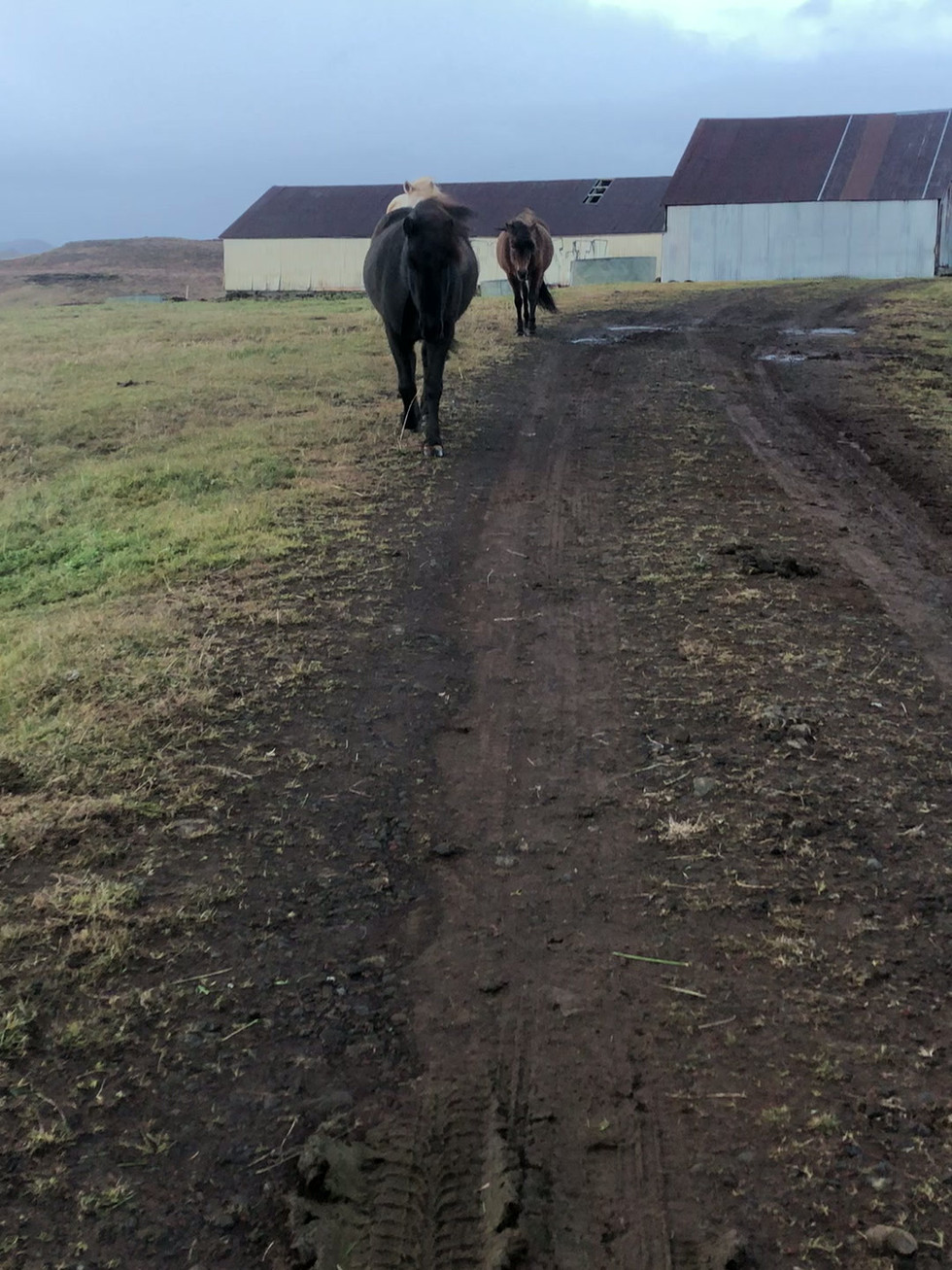
Icelandic Horses
As I departed Þingvellir National Park, I encountered a group of Icelandic horses and paused to greet them. I was particularly drawn to the dark brown horse with the black mane. Although I suspect their curiosity was mainly to check if I had food, this was a delightful moment on my final day in the country.
The Icelandic horse is a compact, resilient, and lively breed recognized for its distinctive five gaits, reliable footing, dense winter coat, and amicable disposition. Although they fall under the pony classification, they are commonly called horses because of their great strength. They were brought to Iceland by Norse settlers over 1,000 years ago and have been bred in total isolation ever since.


Last Night of Exploring
Driving Iceland’s Ring Road offers a transformative experience, highlighting the dramatic contrast between volcanic landscapes and glaciers while encouraging travelers to embrace both planning and spontaneous detours. The journey promises a unique, life-changing adventure for those willing to embark on its scenic, ever-changing route.
Offering more than just scenic views, travelers are left with lasting memories of Iceland's mossy tundra, fierce winds, and dramatic glaciers. Whether the trip lasted a week or longer, this journey through the land of fire and ice makes the vast, ancient landscape feel intimately accessible. The true heart of the experience lies in unexpected detours and flexible exploration. Embracing the island’s pace ensures a memorable trip, with memories that sustain the spirit of adventure until the next visit.


Comments